Part of a Series of Notes about Dunsop Bridge and other Hodder Valley Communities

At the heart of Great Britain, in the centre of the Forest of Bowland, sits the pretty, well-kept village of Dunsop Bridge.
Just 9 miles northwest of the Ribble valley town of Clitheroe, this tiny settlement is often celebrated as the geographic centre of the United Kingdom, though the true bullseye lies 4.5 miles north at Whitendale Hanging Stones.
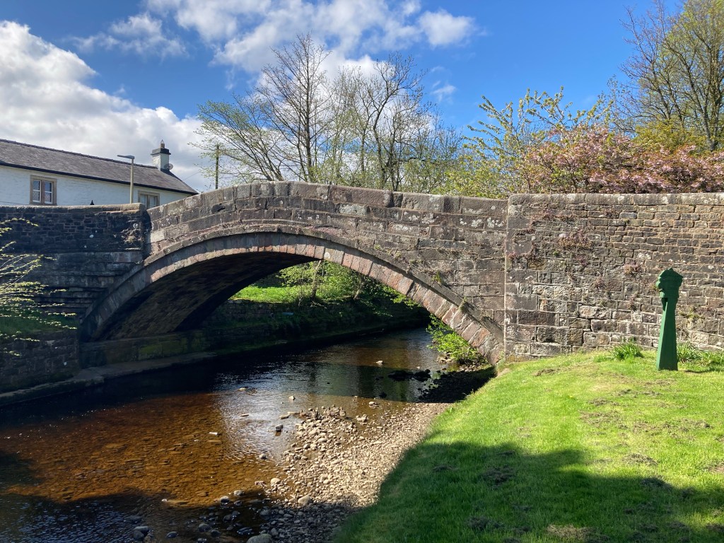
Where the River Dunsop merges with the River Hodder, a sturdy early 19th-century bridge anchors the village to the landscape, its picturesque, and photogenic, setting making it a magnet for walkers from around the world eager to explore the wider countryside, classed as an Area Of Natural Beauty and renowned as one of the most beautiful parts of Great Britain.
Here we look at the history of the village, and uncover some revealing facts about its surprisingly young and humble origins.
An Ancient Whisper in the River’s Name
The name Dunsop whispers of a long distant past, its spring the Brythonic languages spoken by Britain’s sub-Roman inhabitants. It is thought to describe either a “hill by a marsh”, or “fort in a wet area”, Dun meaning “hill” or “fort” in Old English, and sop stemming from the Old English sopp, meaning a wet or marshy place.
In historical records “Dunsop” first appears in a 934 charter when King Aethelstan, the ‘First King of England’, granted the territory of Amounderness (essentially what we now call the Fylde Plains) to St Peter’s Church in York. The document wavers between ‘fons’ (spring) and ‘pons’ (bridge), hinting at an early settlement or feature tied to the river.
This linguistic thread suggests that the area held significance long before the village took shape, a place where a British-speaking population named the waters that define it still.
Yet, the Dunsop Bridge we know today is a younger creation, its story tied closer to that of the 19th century and its industrial pulse, as the village’s location, on a low-lying floodplain, drained by rivers fed by Bowland’s notoriously high rainfall, (in August 1967, 117mm of rain fell in just 90 minutes) was never an obvious spot for settlement.
A single smithy, possibly linked to what is now St George’s Church, and a couple of houses across the bridge (one home to Dunsop Bridge Working Men’s Club) were all that stood here in the mid-1800s, as shown on early Ordnance Survey maps. Before that time, and the construction of most of the sturdy sandstone bridges crossing the rivers in this valley, the neighbouring hamlet of Beatrix was the largest community here.
The risk of flooding kept the hamlet small until opportunity knocked.

The Whitewell Mining Boom
Enter the Whitewell Mining Company, formed in the 1860s to tap into Bowland’s silver-bearing lead ores.
Mining here wasn’t new, Romans dug these hills, and medieval records show sporadic extraction tied to lead prices; when prices soared, Bowland’s ores were worth the effort; when they dipped, the work stalled.
The company, backed by local investors like Peregrine Towneley of Burnley and brewer Matthew Brown, alongside Welsh mining experts from Denbighshire, brought fresh energy. By 1866, they’d built 11 cottages to house a wave of workers, many hailing from Wales and Cornwall, where mining traditions run deep.

A 1871 census paints a vivid picture of the community’s nature; migrants from places as far-flung as Flintshire, Denbighshire, Truro, St Austell, Glasgow and Drogheda in Ireland mingled with locals, their lives all relying on the output of Brennand Mine.
Families like the Hughes, Robinsons, Rickets, Dennises, Snells and Hinsleys, some with roots in nearby Slaidburn, Longridge and Chipping filled these new homes. A provision dealer, Mr. Charley, kept both farmers and miners fed, while a gas lamp still visible on one Trough-side house hints at the era’s modest comforts.
But the boom was fleeting.
The mine peaked in 1867, yielding 630 tons of ore, 489.5 tons of lead, and 2060 ounces of silver. By 1874, production had crashed, with only 1½ tons of ore being produced, and the company folded, auctioning off everything including the items listed below;
- Four iron dwelling-houses
- Waterwheels
- Water-pressure hoisting and pumping engines
- Crushing mills
- A ‘large cistern’
- Wrought and cast iron pipes
- About 20 tons of tram metals and sleepers
- Iron wagons
- Double purchase winch
- Double-blast smith’s bellows
- A varied assortment of smith’s tools, anvils, irons, miners hammers, picks drills, spades, jiggers, buddles, washing tools, and a large number of other articles associated with mining pursuits
- A large quantity of office fixtures including iron safe and copying press
- Horse gears, hay cutter, and provender chests
A Village Shaped by Floods and Fortune
The mining bust left its mark. Most workers moved on, chasing work elsewhere, but the cottages endured, forming the nucleus of modern-day Dunsop Bridge, although the village’s flood-prone setting, a challenge even today, shaped its slow growth.
Any traces of the temporary shacks, built for the miners at nearby Footholme, that were left after their iron had been sold, were swept away by subsequent floods, leaving only a lone “bus shelter with a chimney” where the mine’s check office once stood.
Yet, even though discarded by the industry that created it, the village itself was not entirely abandoned by the community that had developed there, which persisted and gave it the unique and charming character it has now.
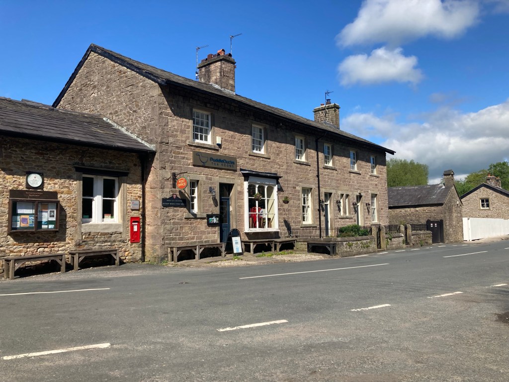
Visitors today will find a tidy village green, with a resident population of very tame ducks (which will unceasingly pester you for food), Puddleducks Tea Rooms and Post Office, (very popular with cyclists and motorbikers), a brand new Village Hall, and just up the hill outside the village St Huberts Roman Catholic Church, a handsome building designed by Pugin with a rather interesting story of its own (See link to read more).

Recently visiting Dunsop has become a lot easier, with the re-instatement of a vital bus service from Clitheroe, the Number 11, which passes through Whitewell, Newton and Slaidburn too.
This year (2025) it is the village’s turn to host the Hodder Valley Show, which rotates through Slaidburn-Newton-Dunsop (the only country show that does this). It is well-worth the trip, and it gives you a chance to really appreciate the true nature of this beautiful neck-of -the-woods and what makes its present-day communities tick.

A ramble by the rivers side
Is pleasant in the summer
Where dragon flies on gauze wings hide
And the bee’s a minstrel hummer
A ramble by the river side
No walk so sweet can be
To see the creeping waters glide
And hear the humble bee
(From A Ramble by the Riverside by John Clare (1793-1864))

If you enjoyed this article please consider showing your appreciation by buying me a coffee, every contribution will go towards researching and writing future articles,
Thank-you for visiting my site,
Alex Burton-Hargreaves
(Aug 2025)

By coincidence, I plan to be there next weekend!
LikeLiked by 1 person
It’s a lovely little place, I hope the weather’s ok for you!
LikeLike
It’s a lovely little spot, let’s hope the weather’s ok for you!
LikeLiked by 1 person
When you talk of the lead mine, do you mean Sykes mine up the Trough road past Smelt Mill Cottage, Bowland Mountain Rescue’s property?
Interesting post.
LikeLiked by 1 person
There was 3 or 4 at Brennand and Whitendale, 2 at Sykes and 2 (I think) at Moor End, those are the ones near Dunsop and there are others in Bowland, the Whitewell Mining Co ran the ones at Brennand and Whitendale, Brennand being the main mine, I’m planning on writing about Sykes in the future, (the list of things I’m planning on writing about just gets longer and longer!)
LikeLiked by 1 person
Thanks for that.
LikeLike
A very nice piece but though you tagged it you omitted to mention that this area is only ‘administered’ by Lancashire.
Historically and in reality it is in the West Riding of Yorkshire.
LikeLiked by 1 person
Thank-you, yes it is in Yorkshire but I remember that I didn’t mention it as I didn’t consider it directly relevant to the piece.
I must admit that when I’m writing about that part of the world there is a little devil that sits on my shoulder and tells me to type that they are in Lancashire, just to rile up any Yorkshiremen that are reading, as a Lancastrian it would be my honour-bound duty to do so but of course I’m better than that!
LikeLike